


DoD's Defence Meteorological Satellite Program (DMSP) |
|||
The Breathtaking View from 830 Kilometers Altitude Polar Orbit | |||
|---|---|---|---|
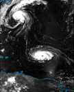 Hurricane Iris in the visible |
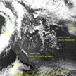 Western U. S. snow & ice cover |
 Eastern U. S. snow & ice cover | |
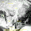
 Lightning Images (Lightning strokes are the horizontal white lines in the gulf) |
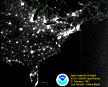 City Lights at Night (visible) |
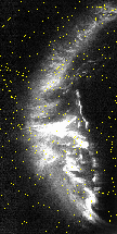 Auroral Lights | |
 City Lights at Night (visible) | |||
Imagery produced with DMSP data at NGDC with funding by NOAA/DOC
Last modified prior to September, 2000 by the Windows Team
The source of this material is Windows to the Universe, at http://windows2universe.org/ from the National Earth Science Teachers Association (NESTA). The Website was developed in part with the support of UCAR and NCAR, where it resided from 2000 - 2010. © 2010 National Earth Science Teachers Association. Windows to the Universe® is a registered trademark of NESTA. All Rights Reserved. Site policies and disclaimer.